

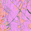
Bản đồ kế hoạch sử dụng đất Phường 11 Quận Tân Bình năm 2025, 2026
Phân tích Tổng quan về Bản đồ Kế hoạch Sử dụng Đất Phường 11, Tân Bình, TP. Hồ Chí Minh
Bản đồ kế hoạch sử dụng đất là công cụ quan trọng trong quản lý đô thị, giúp định hướng phát triển kinh tế - xã hội, bảo vệ môi trường và nâng cao chất lượng cuộc sống người dân. Phường 11, quận Tân Bình, TP. Hồ Chí Minh là khu vực có tốc độ đô thị hóa nhanh, nên việc phân tích bản đồ kế hoạch sử dụng đất tại đây càng trở nên cấp thiết.
1. Giới thiệu về Phường 11, Tân Bình, TP. Hồ Chí Minh
Phường 11 thuộc quận Tân Bình, nằm ở phía Tây Bắc TP. Hồ Chí Minh, có diện tích khoảng 0,5 km², dân số hơn 20.000 người. Khu vực này có mật độ dân cư cao, hệ thống hạ tầng phát triển, đồng thời là trung tâm thương mại, dịch vụ sôi động. Việc quy hoạch sử dụng đất tại đây đóng vai trò quan trọng trong việc cân bằng giữa phát triển kinh tế và đảm bảo môi trường sống.
2. Khái quát về Bản đồ Kế hoạch Sử dụng Đất
Bản đồ kế hoạch sử dụng đất Phường 11 thể hiện chi tiết các loại đất được phân bổ theo mục đích sử dụng, bao gồm:
- Đất ở đô thị: Khu dân cư, chung cư, nhà phố.
- Đất thương mại, dịch vụ: Trung tâm mua sắm, văn phòng, nhà hàng.
- Đất công cộng: Trường học, bệnh viện, công viên.
- Đất giao thông: Đường phố, bến xe.
- Đất cây xanh, mặt nước: Công viên, hồ điều hòa.
Bản đồ này được xây dựng dựa trên quy hoạch tổng thể của TP. Hồ Chí Minh và các quy định pháp luật về quản lý đất đai.
3. Mục tiêu của Kế hoạch Sử dụng Đất
- Phát triển đô thị bền vững: Đảm bảo cân bằng giữa xây dựng hạ tầng và bảo tồn không gian xanh.
- Nâng cao chất lượng sống: Phân bổ hợp lý đất ở, dịch vụ công cộng.
- Thúc đẩy kinh tế: Phát triển các khu thương mại, dịch vụ để thu hút đầu tư.
- Bảo vệ môi trường: Duy trì diện tích cây xanh, mặt nước để giảm thiểu ô nhiễm.
4. Hiện trạng Sử dụng Đất tại Phường 11
Theo số liệu mới nhất, Phường 11 có cơ cấu sử dụng đất chủ yếu tập trung vào:
- Đất ở đô thị: Chiếm khoảng 60% diện tích.
- Đất thương mại, dịch vụ: Khoảng 20%.
- Đất công cộng: 10%.
- Đất giao thông và cây xanh: 10%.
Tuy nhiên, do quá trình đô thị hóa nhanh, một số khu vực đang đối mặt với tình trạng quá tải hạ tầng, thiếu không gian công cộng.
5. Định hướng Quy hoạch đến năm 2030
Theo kế hoạch, Phường 11 sẽ tập trung vào:
- Mở rộng đất công cộng: Xây dựng thêm trường học, bệnh viện, công viên.
- Phát triển đất thương mại: Nâng cấp các trung tâm thương mại hiện có.
- Cải thiện giao thông: Mở rộng đường phố, xây dựng bến xe công cộng.
- Bảo tồn cây xanh: Duy trì và phát triển các công viên, hồ điều hòa.
6. Tác động của Quy hoạch đến Đời sống Người dân
- Tích cực: Nâng cao chất lượng sống, giảm ùn tắc giao thông, tăng cường dịch vụ công.
- Thách thức: Giá đất tăng cao, nguy cơ thiếu hụt nhà ở giá rẻ.
7. Các Vấn đề Cần Giải quyết
- Quản lý đất đai chặt chẽ: Tránh tình trạng lấn chiếm, sử dụng sai mục đích.
- Đảm bảo công bằng xã hội: Hỗ trợ người dân có thu nhập thấp tiếp cận nhà ở.
- Bảo vệ môi trường: Giảm thiểu ô nhiễm từ các công trình xây dựng.
8. So sánh với Các Phường Lân cận
Phường 11 có quy hoạch tương đồng với các phường khác trong quận Tân Bình nhưng tập trung nhiều hơn vào phát triển thương mại do vị trí trung tâm.
9. Cơ hội và Thách thức trong Tương lai
- Cơ hội: Thu hút đầu tư, phát triển kinh tế.
- Thách thức: Áp lực dân số, quá tải hạ tầng.
10. Kết luận
Bản đồ kế hoạch sử dụng đất Phường 11 là nền tảng quan trọng để phát triển bền vững. Việc thực hiện hiệu quả sẽ mang lại lợi ích lâu dài cho người dân và nền kinh tế địa phương.
10 Câu hỏi Liên quan đến Bản đồ Kế hoạch Sử dụng Đất Phường 11, Tân Bình
- Bản đồ kế hoạch sử dụng đất Phường 11 được cập nhật theo chu kỳ nào?
- Có bao nhiêu loại đất chính được quy hoạch tại Phường 11?
- Diện tích đất thương mại, dịch vụ chiếm bao nhiêu phần trăm tổng diện tích?
- Kế hoạch phát triển đất công cộng tại Phường 11 đến năm 2030 như thế nào?
- Những thách thức lớn nhất trong quá trình thực hiện quy hoạch là gì?
- Phường 11 có những biện pháp gì để bảo vệ môi trường trong quy hoạch đất đai?
- Giá đất tại Phường 11 biến động ra sao sau khi công bố quy hoạch?
- Người dân có thể tham gia góp ý vào bản đồ quy hoạch như thế nào?
- So với các phường khác trong quận Tân Bình, quy hoạch đất đai của Phường 11 có gì khác biệt?
- Các dự án hạ tầng trọng điểm nào sẽ được triển khai tại Phường 11 trong thời gian tới?
Bài viết đã cung cấp cái nhìn tổng quan về bản đồ kế hoạch sử dụng đất Phường 11, đồng thời giải đáp các thắc mắc phổ biến liên quan. Việc hiểu rõ quy hoạch sẽ giúp người dân và nhà đầu tư có định hướng phát triển phù hợp.
Tra cứu Bản đồ kế hoạch sử dụng đất Phường 11 Quận Tân Bình năm 2025, 2026
Bạn hãy truy cập website guland.vn hoặc tải ứng dụng App Guland trên Android và Ios hoặc truy cập https://guland.vn/kho-ban-do/ke-hoach/tp-ho-chi-minh/quan-tan-binh/phuong-11
Hỏi đáp về Bản đồ kế hoạch sử dụng đất Phường 11, Tân Bình, TP. Hồ Chí Minh
10 Câu Hỏi Đáp Liên Quan Đến Bản Đồ Kế Hoạch Sử Dụng Đất Phường 11, Tân Bình, TP. Hồ Chí Minh
1. Bản đồ kế hoạch sử dụng đất Phường 11, Tân Bình là gì?
Bản đồ kế hoạch sử dụng đất Phường 11, Tân Bình là tài liệu quy hoạch chi tiết, thể hiện phân bổ các loại đất theo mục đích sử dụng như đất ở, đất thương mại, đất công cộng, đất giao thông... trong một giai đoạn cụ thể. Bản đồ này được UBND TP. Hồ Chí Minh phê duyệt nhằm định hướng phát triển kinh tế - xã hội, đảm bảo quản lý đất đai hiệu quả.
2. Mục đích của bản đồ quy hoạch sử dụng đất Phường 11?
- Định hướng phát triển đô thị, cân bằng giữa các nhu cầu dân sinh và kinh tế.
- Phân vùng rõ ràng các loại đất để tránh tranh chấp, lấn chiếm.
- Đảm bảo hạ tầng đồng bộ, nâng cao chất lượng sống cho người dân.
- Thu hút đầu tư vào các dự án phù hợp với quy hoạch.
3. Thời hạn áp dụng quy hoạch đất Phường 11, Tân Bình?
Theo quyết định của UBND TP. Hồ Chí Minh, kế hoạch sử dụng đất Phường 11 thường có thời hạn từ 5–10 năm, tùy vào giai đoạn quy hoạch. Hiện tại, bản đồ quy hoạch đến năm 2025 đang được áp dụng, với khả năng điều chỉnh nếu có thay đổi về chiến lược phát triển.
4. Cách tra cứu bản đồ quy hoạch đất Phường 11?
Người dân có thể tra cứu thông tin quy hoạch bằng các cách sau:
- Trực tuyến: Truy cập cổng thông tin quy hoạch TP. Hồ Chí Minh (https://thongtinquyhoach.hochiminhcity.gov.vn).
- Trực tiếp: Liên hệ Phòng Tài nguyên và Môi trường quận Tân Bình hoặc UBND Phường 11 để xem bản đồ giấy.
- Ứng dụng: Sử dụng app "Quy hoạch TP.HCM" trên điện thoại.
5. Đất Phường 11 được phân loại như thế nào trong quy hoạch?
Các loại đất chính bao gồm:
- Đất ở (ODT): Chiếm tỷ lệ lớn, tập trung tại các khu dân cư như đường Lê Văn Sỹ, Nguyễn Kiệm.
- Đất thương mại - dịch vụ (TMDV): Dọc các trục đường chính như Trường Chinh, Hoàng Văn Thụ.
- Đất công cộng: Trường học, bệnh viện, công viên (ví dụ: Công viên Gia Định).
- Đất giao thông: Mở rộng đường Nguyễn Thái Sơn, Bạch Đằng.
6. Dự án nào đang triển khai theo quy hoạch Phường 11?
- Khu đô thị mới Tân Bình: Cải tạo khu dân cư cũ, xây dựng chung cư cao tầng.
- Tuyến Metro số 2 (Bến Thành - Tham Lương): Đi qua khu vực Phường 11, nâng cao kết nối giao thông.
- Trung tâm thương mại: Quy hoạch dọc đường Hoàng Văn Thụ.
7. Làm sao để biết đất mình đang ở có thuộc diện quy hoạch?
- Kiểm tra Sổ đỏ (Giấy chứng nhận quyền sử dụng đất): Mục "Thông tin quy hoạch" ghi rõ loại đất và hạn chế (nếu có).
- Xin Trích lục quy hoạch tại Văn phòng đăng ký đất đai quận Tân Bình.
- Tra cứu bản đồ số hóa trên cổng thông tin TP. HCM.
8. Quy hoạch đất ảnh hưởng thế nào đến giá bất động sản Phường 11?
- Đất thuộc diện quy hoạch thương mại hoặc giao thông thường tăng giá mạnh.
- Đất quy hoạch công cộng (cây xanh, trường học) có thể bị hạn chế xây dựng, giảm giá trị đầu tư ngắn hạn.
- Khu vực gần tuyến Metro được đánh giá cao về tiềm năng sinh lời.
9. Có được xây nhà trên đất đang trong diện quy hoạch không?
- Nếu đất chưa có thông báo thu hồi, chủ sở hữu vẫn được xây dựng tạm thời nhưng phải đảm bảo tuân thủ quy định (không xây kiên cố).
- Khi Nhà nước công bố giải tỏa, việc đền bù sẽ căn cứ vào giá đất quy hoạch và hiện trạng sử dụng.
10. Thủ tục khiếu nại nếu quy hoạch ảnh hưởng đến quyền lợi cá nhân?
- Gửi đơn khiếu nại đến UBND Phường 11 hoặc Thanh tra quận Tân Bình.
- Cung cấp giấy tờ chứng minh quyền sử dụng đất và bản sao quy hoạch.
- Nếu không đồng ý với kết quả giải quyết, có thể khởi kiện ra tòa hành chính.
Kết Luận
Bản đồ quy hoạch sử dụng đất Phường 11, Tân Bình là công cụ quan trọng giúp người dân và nhà đầu tư nắm bắt định hướng phát triển khu vực. Việc hiểu rõ thông tin quy hoạch giúp tránh rủi ro pháp lý và tối ưu hóa giá trị bất động sản. Để cập nhật chính xác nhất, nên thường xuyên kiểm tra thông tin từ cơ quan chức năng hoặc cổng thông tin điện tử của thành phố.
Thông tin bài viết được tổng hợp tự động bởi công nghệ trí tuệ nhân tạo ChatGPT, thông tin chỉ mang tính chất tham khảo, chúng tôi không chịu trách nhiệm về tính chính xác của thông tin. Nếu thông tin chưa đúng vui lòng liên hệ [email protected] để chúng tôi sửa lại.